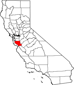
Santa Clara County, California
| County of Santa Clara | |||
|---|---|---|---|
| — County — | |||
 |
|||
|
|||
 |
|||
| Country | United States | ||
| State | California | ||
| Region/Metro Area | San Francisco Bay Area | ||
| Incorporated | 1850 | ||
| Named for | Mission Santa Clara de Asís | ||
| County seat | San Jose | ||
| Largest City | San Jose | ||
| Area | |||
| - Total | 1,304 sq mi (3,377.3 km2) | ||
| - Land | 1,291 sq mi (3,343.7 km2) | ||
| - Water | 13 sq mi (33.7 km2) | ||
| Population (2000) | 1,682,585 | ||
| - Density | 1,409/sq mi (544/km2) | ||
| Time zone | Pacific Standard Time (UTC-8) | ||
| - Summer (DST) | Pacific Daylight Time (UTC-7) | ||
| Area code(s) | 408, 650 | ||
| Website | www.sccgov.org | ||
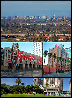
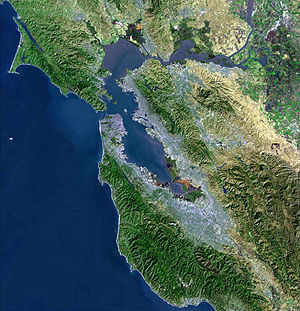
Santa Clara County is a county located at the southern end of the San Francisco Bay Area in the U.S. state of California. As of 2000 it had a population of 1,682,585. The U.S. Census estimate for 2008 was 1,764,499.[1] The county seat is San Jose. The highly urbanized Santa Clara Valley within Santa Clara County is also known as Silicon Valley. Santa Clara is the most populous county in the Bay Area region.
Contents |
History
Santa Clara County was one of the original counties of California, formed in 1850 at the time of statehood. The original inhabitants included the Ohlone, residing on Coyote Creek and Calaveras Creek. Part of the county's territory was given to Alameda County in 1853.
The county is named after Mission Santa Clara, which was established in 1777, and named for Saint Clare of Assisi, Italy.
In 1882, Santa Clara County tried to levy taxes upon property of the Southern Pacific Railroad within county boundaries. The result was the U.S. Supreme Court case of Santa Clara County v. Southern Pacific Railroad, 118 U.S. 394 (1886), in which the Court extended Due Process rights to artificial legal entities.
After two centuries of an agricultural economy started by the Spanish missionaries, the focus has shifted to technology. This trend is not new. Hewlett Packard was founded in 1939, and Fairchild Semiconductor along with other early innovators were located in the county by the late 1950s. The term "Silicon Valley" was itself coined in 1971. The trend accelerated in the 1980s and 1990s, and agriculture has been nearly eliminated from the northern part of the county. Today, Santa Clara County is the headquarters for such companies as Apple, Sun Microsystems, Hewlett Packard, Google, Yahoo, eBay, Intel and many others. The county is the main area of the Silicon Valley, which includes several other counties both north and south of Santa Clara.
Geography
According to the U.S. Census Bureau, the county has a total area of 1,304 square miles (3,377 km²), of which 1,291 square miles (3,343 km²) are land and 13 square miles (34 km²) (1.02%) are water.
The San Andreas Fault runs along the Santa Cruz Mountains in the south of the county.
Cities, towns, and neighborhoods
Incorporated cities and towns
There are 15 incorporated cities and towns in the county:
- San Jose, which includes the former cities/communities of:
- Alum Rock,
- Cambrian Park,
- Willow Glen,
- East San Jose, and
- Alviso
- Campbell
- Cupertino
- Gilroy
- Los Altos
- Los Altos Hills
- Los Gatos
- Milpitas
- Monte Sereno
- Morgan Hill
- Mountain View
- Palo Alto
- Santa Clara
- Saratoga
- Sunnyvale
Unincorporated communities
Census-designated places
- Buena Vista
- Burbank
- East Foothills
- Fruitdale
- Lexington Hills
- Loyola also known as Loyola Corners
- San Martin
- Seven Trees
- Stanford
- Sunol-Midtown
Other unincorporated communities
- Bell Station also known as Bell's Station and Hollenbeck's Station.
- Casa Loma also known as Loma Chiquita.
- Chemeketa Park (part of Lexington Hills CDP)
- Coyote also known as Burnett circa 1860-1882.
- Redwood Estates (part of Lexington Hills CDP)
- Rucker
- San Antonio also known as Deforest circa 1892-1924.
Former townships
- Almaden Township - Present-day Almaden Valley, Cambrian Park and portions of Campbell and Los Gatos.
- Alviso Township - Present-day Alviso.
- Burnett Township - Present-day Coyote, Santa Teresa and Morgan Hill.
- Fremont Township - Present-day Palo Alto, Sunnyvale, Mountain View, Los Altos, Los Altos Hills and part of Cupertino.
- Gilroy Township - Present-day Gilroy and San Martin.
- Milpitas Township - Present-day Milpitas.
- Redwood Township - Present-day Los Gatos, Monte Sereno, Saratoga, Redwood Estates and portions of Cupertino and Campbell.
- San Jose Township - Most of present-day San Jose.
- Santa Clara Township - Present-day Santa Clara and portions of San Jose, Cupertino and Campbell.
Adjacent counties
- San Benito County, California - south
- Santa Cruz County, California - south, southwest
- San Mateo County, California - northwest
- Alameda County, California - north
- Stanislaus County, California - east
- Merced County, California - southeast
 |
San Mateo County | Alameda County | |
|
| Stanislaus County | ||||
| Santa Cruz County | San Benito County and Santa Cruz County | Merced County |
National protected area
- Don Edwards San Francisco Bay National Wildlife Refuge (part)
Transportation infrastructure
Freeways and expressways
The county has an extensive freeway system and a separate expressway system. Expressways in California are distinct from freeways; although access to adjoining properties is eliminated, at-grade intersections are allowed. However, unlike expressways virtually everywhere else in California, the Santa Clara County expressways were built, signed, and maintained as county roads; they are not maintained by Caltrans, although they are patrolled by the California Highway Patrol.
There is also a large street network dominated by four- and six-lane arterials. Some of the newer boulevards (primarily in the West Valley) are divided with landscaped medians.
Major highways
|
|
County routes
|
|
Other roads
- The Alameda
- Infinite Loop
Mass transit
Santa Clara County has consolidated its transportation services into the Santa Clara Valley Transportation Authority, which operates a rapidly expanding light rail system and a large system of bus routes. It also manages certain county-funded highway and expressway projects.
Besides SCVTA, the County is also served by Caltrain commuter rail service, and the ACE Train system, which runs between San Jose and Stockton.
County Bicycle Network
The Santa Clara Valley Transportation Authority is establishing a bicycle network through out the county. Santa Clara County Bicycle network is part of the San Francisco Bay Area, Regional Bikeway Network.
Ports
The county's main airport is Norman Y. Mineta San José International Airport (SJC). It is a U.S. Customs and Border Protection port of entry.[2] Moffett Federal Airfield (NUQ), a former U.S. Naval Air Station, is used by the Air National Guard, NASA, Lockheed Martin, and Google.[3] There are also smaller general aviation airports in Palo Alto (PAO), San Jose (RHV), and San Martin (E16).
The county has no commercial seaports, although small boats can access San Francisco Bay from several points. Like many other Bay Area counties, it is dependent upon the Port of Oakland for transport of ocean cargo.
Demographics
| Historical populations | |||
|---|---|---|---|
| Census | Pop. | %± | |
| 1860 | 11,912 |
|
|
| 1870 | 26,246 | 120.3% | |
| 1880 | 35,039 | 33.5% | |
| 1890 | 48,005 | 37.0% | |
| 1900 | 60,216 | 25.4% | |
| 1910 | 83,539 | 38.7% | |
| 1920 | 100,676 | 20.5% | |
| 1930 | 145,118 | 44.1% | |
| 1940 | 174,949 | 20.6% | |
| 1950 | 290,547 | 66.1% | |
| 1960 | 642,315 | 121.1% | |
| 1970 | 1,064,714 | 65.8% | |
| 1980 | 1,295,071 | 21.6% | |
| 1990 | 1,497,577 | 15.6% | |
| 2000 | 1,682,585 | 12.4% | |
As of the census[4] of 2000, there were 1,682,585 people, 565,863 households, and 395,538 families residing in the county. The population density was 1,304 people per square mile (503/km²). There were 579,329 housing units at an average density of 449 per square mile (173/km²). The racial makeup of the county was 53.83% White, 2.80% Black or African American, 0.67% Native American, 25.56% Asian, 0.34% Pacific Islander, 12.13% from other races, and 4.66% from two or more races. 23.98% of the population were Hispanic or Latino of any race. 6.7% were of German and 5.4% English ancestry according to Census 2000. 54.7% spoke English, 17.6% Spanish, 5.7% Vietnamese, 5.3% Chinese or Mandarin, 3.3% Tagalog and 1.2% Korean as their first language.
There were 565,863 households out of which 34.90% had children under the age of 18 living with them, 54.90% were married couples living together, 10.00% had a female householder with no husband present, and 30.10% were non-families. 21.40% of all households were made up of individuals and 5.90% had someone living alone who was 65 years of age or older. The average household size was 2.92 and the average family size was 3.41.
In the county the population was spread out with 24.70% under the age of 18, 9.30% from 18 to 24, 35.40% from 25 to 44, 21.00% from 45 to 64, and 9.50% who were 65 years of age or older. The median age was 34 years. For every 100 females there were 102.80 males. For every 100 females age 18 and over, there were 101.90 males.
The median income for a household in the county was $74,335, and the median income for a family was $81,717. Males had a median income of $56,240 versus $40,574 for females. The per capita income for the county was $32,795. About 4.90% of families and 7.50% of the population were below the poverty line, including 8.40% of those under age 18 and 6.40% of those age 65 or over.
Santa Clara County has the highest median household income of any county in California. On April 30, 2010, the California Department of Finance released a population estimate of 1,880,876 residents living within the county as of January 1st, 2010.[5]
Government and politics

| Year | DEM | GOP | Others |
|---|---|---|---|
| 2008 | 69.6% 460,128 | 28.7% 189,229 | 1.7% 12,199 |
| 2004 | 63.9% 386,100 | 34.6% 209,094 | 1.4% 8,622 |
| 2000 | 60.7% 332,490 | 34.4% 188,750 | 4.9% 26,889 |
| 1996 | 56.9% 297,639 | 32.2% 168,291 | 11.0% 57,361 |
| 1992 | 49.2% 296,265 | 28.4% 170,870 | 22.4% 134,920 |
| 1988 | 51.3% 277,810 | 47.0% 254,442 | 1.7% 9,276 |
| 1984 | 43.7% 229,865 | 54.8% 288,638 | 1.5% 8,136 |
| 1980 | 35.0% 166,995 | 48.0% 229,048 | 17.0% 80,960 |
| 1976 | 46.9% 208,023 | 49.5% 219,188 | 3.6% 15,927 |
| 1972 | 45.6% 208,506 | 51.9% 237,334 | 2.5% 11,453 |
| 1968 | 48.4% 173,511 | 45.6% 163,446 | 6.0% 21,410 |
| 1964 | 63.1% 202,249 | 36.6% 117,420 | 0.3% 858 |
| 1960 | 47.1% 117,667 | 52.7% 131,735 | 0.3% 690 |
Santa Clara is a strongly Democratic county in presidential and congressional elections. The last Republican to win a majority in the county was Ronald Reagan in 1984. With the exceptions of Los Altos Hills, Monte Sereno, and Saratoga, all of the cities, towns, and the unincorporated areas of Santa Clara County have more registered Democrats than Republicans.[6] In the 2008 US Presidential Election, Democratic nominee Barack Obama carried every city and town in the county, as well as the unincorporated areas.[7]
In the House of Representatives, all of California’s 15th and 16th districts, as well as some of the 11th and 14th districts, are in the county and are all held by Democrats: Jerry McNerney in the 11th, Anna Eshoo in the 14th, Mike Honda in the 15th, and Zoe Lofgren in the 16th.
In the State Assembly, all of the 22nd, 23rd, and 24th districts, as well as parts of the 20th, 21st, 27th, and 28th districts are in the county. The districts are all held by Democrats; in order of district number they are Alberto Torrico, Ira Ruskin, Paul Fong, Joe Coto, Jim Beall, Bill Monning, and Anna Caballero.
In the State Senate, all of the 13th as well as parts of the 10th, 11th, and 15th districts are in the county. The 10th, 11th, and 13th districts are held by Democrats, Ellen Corbett, Joe Simitian, and Elaine Alquist, respectively. The 15th is held by Republican Abel Maldonado.
Following the passage of Proposition 8, Santa Clara County joined San Francisco and Los Angeles in a lawsuit, becoming, along with San Francisco and Los Angeles, the first governmental entities in the world to sue for same sex marriage.[8] The county is among one of three counties in California to establish a separate department to deal with corrections pursuant to California Government Code §23013, the Santa Clara County Department of Corrections, along with Napa County and Madera County.
Parks
Santa Clara County has an extensive park system, much of it founded in the major park expansion of the late 1970s. Some of the parks within the county are:
- Almaden Quicksilver County Park
- Grant Ranch Park
- Henry W. Coe State Park
- Sanborn Park
- Vasona Park
Open space preserves include:
- El Sereno Open Space Preserve
Libraries
Santa Clara County Library, headquartered in Los Gatos, is a public library system serving the communities and cities of Campbell, Cupertino, Gilroy, Los Altos, Los Altos Hills, Milpitas, Monte Sereno, Morgan Hill, Saratoga, and all unincorporated areas of the county.[9]
Sister counties
To promote friendship and understanding and to build bridges with countries of origin for various ethnic populations in the county, the County of Santa Clara has created a Sister County Commission to coordinate the program. As of 2009, there are three sister counties:[10]
 - Province of Florence, Italy
 - Moscow Area, Russia
 - Hsinchu County, Taiwan
See also
- Santa Clara Valley
- Committee for Green Foothills
- Hiking trails in Santa Clara County
- Old Almaden Winery
- Santa Clara County expressway system
- List of school districts in Santa Clara County, California
References
- ↑ http://www.census.gov/popest/counties/tables/CO-EST2008-01-06.xls
- ↑ http://www.cbp.gov/xp/cgov/toolbox/contacts/ports/ca/2834.xml
- ↑ Verne Kopytoff (September 13, 2007). "Google founders pay NASA $1.3 million to land at Moffett Airfield". San Francisco Chronicle. http://sfgate.com/cgi-bin/article.cgi?f=/c/a/2007/09/13/BUPRS4MHA.DTL&tsp=1. Retrieved 2007-09-23.
- ↑ "American FactFinder". United States Census Bureau. http://factfinder.census.gov. Retrieved 2008-01-31.
- ↑ http://www.dof.ca.gov/research/demographic/reports/estimates/e-1/2009-10/documents/E-1_2010.xls
- ↑ http://www.sos.ca.gov/elections/ror/ror-pages/15day-presgen-08/politicalsub.pdf
- ↑ http://www.sos.ca.gov/elections/sov/2008_general/ssov/5-pres-by-political-districts.pdf
- ↑ [http://news.lp.findlaw.com/hdocs/docs/election2008/20081105-sf-la-prop8-petition.pdf "Herrera Joined by Los Angeles, Santa Clara Counterparts in Suing to Invalidate Prop 8"]. Office of the City Attorney of San Francisco. 2008-11-05. http://news.lp.findlaw.com/hdocs/docs/election2008/20081105-sf-la-prop8-petition.pdf. Retrieved 2008-12-20.
- ↑ "Contact Us." Santa Clara County Library. Retrieved on March 27, 2010.
- ↑ "Sister County Commissions (PRG)". The County of Santa Clara. http://www.sccgov.org/portal/site/sistercountycomm/. Retrieved 2010-01-07.
External links
- Santa Clara Valley Water District - Drinking Water
- Santa Clara County official website
- Santa Clara County governmental committee agendas
- Santa Clara County Planning Office
- List of special districts in Santa Clara County (LAFCo)
- Santa Clara County Library
- Santa Clara County: California's Historic Silicon Valley, a National Park Service Discover Our Shared Heritage Travel Itinerary
|
||||||||||||||||||||
|
||||||||||||||||||||||||||||||||
|
|||||||||||||||||||||||||
|
|||||||||||||||||||||||